Ordnance Survey Maps
Description:
The first Ordnance Survey maps were the Old Series, 1-inch to a mile, maps dating from the early 1830s (in Warwickshire). These maps proved to be far more accurate than those issued previously by private cartographers. By the mid 1800s, demand was increasing for larger scale maps (6-inch to a mile and 25 inch to a mile) so a new survey of the country was conducted.
The larger scale OS maps (known as the County Series maps) were produced in the 1880s and subsequently revised approximately every 20 years. In Warwickshire the 1st edition of the 6-inch Ordnance Survey maps were completed between 1884-1897. These County Series maps were created at scales of 6-inches (1:10,560) and 25-inches to the mile (c.1:2500). Further editions of the County Series were subsequently produced with changes and alterations: 2nd edition 1903-1906, 3rd edition 1912-1917, 4th edition 1925 and 5th edition 1938.
After World War II Ordnance Survey maps were produced at a metric scale and began being produced at 1:1250, 1:2500 and 1:10,000
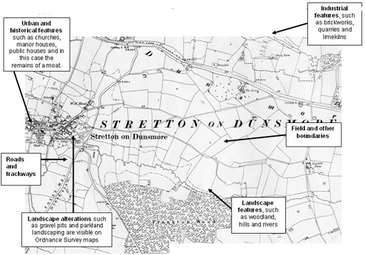
Figure 3: First Edition Ordnance Survey Map 1886 (Scale: Six inches to a mile): Stretton on Dunsmore

Ordnance Survey reproduced under licence (licence no. 100018285)
Click here for larger image
Uses:
Maps are a useful starting point for researching local history and when trying to understand the local landscape and built environment. Ordnance Survey maps can be used to chart more recent changes in landscapes and boundaries, urban development, to locate particular features, to find the location of natural resources, and to identify land use, industry and transport links. When recording a feature it is always useful to note its grid reference.
Ordnance Survey maps can also be compared to other maps in order to identify continuity and change (map regression). This can be achieved by overlaying maps of the same scale; reduction or enlargement of different maps may be necessary to achieve this. When comparing old and modern maps it is also worth remembering the change in scale.
Where to find this source:
- Local Libraries
- County Record Office
- Historic Environment Record

