Aerial Photographs
Description:
There are two types of aerial photograph - vertical and oblique. Vertical photographs are taken from directly above an area, whilst oblique photographs are taken at an angle to the ground. Many aerial photographs are taken specifically for archaeological reasons, although photographs taken for other purposes are also useful. Vertical aerial photographs are available from a number of sources, including those taken by the RAF and the Luftwaffe. However, oblique aerial photographs are often more useful for identifying archaeological features.
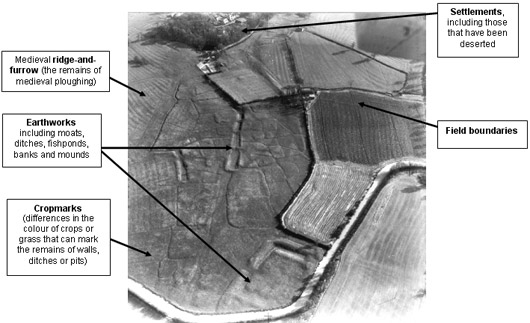
Figure 1: Oblique Aerial Photograph of Wormleighton 
Copyright reserved (Photography by) Cambridge University Collection of Air Photographs
Click here for larger image
Uses:
Aerial photographs are an important source for understanding a landscape. They can provide information on the layout of a landscape, land use and archaeological features. They are particularly useful for identifying features that may not otherwise be visible, namely cropmarks. Cropmarks appear as differences in the colour of crops or grass. They may signify the remains of buried walls, ditches or pits, but they can also be caused by geological features. Oblique photographs often show sites in greater detail because they are usually photographed from a lower altitude, whereas vertical photographs can be used for mapping features. Soil conditions, the type of crops, weather conditions and the time of year can all affect the visibility of crop-marks. Hence it may be necessary to compare photographs from a number of years.
Other features, such as ridge-and-furrow and barrows, may be more readily visible on aerial photographs than on the ground. Aerial photographs can also be used to identify ploughed-out features in the landscape. Thus aerial photographs are especially useful for identifying prehistoric features in the landscape. It is important to compare aerial photographs with Ordnance Survey and other maps when identifying particular features.
Where to find this source:
- Historic Environment Record
- National Monuments Record
- Record Office
- Limited availability on the Internet

