The Landscape Of Warwickshire
By Della Hooke

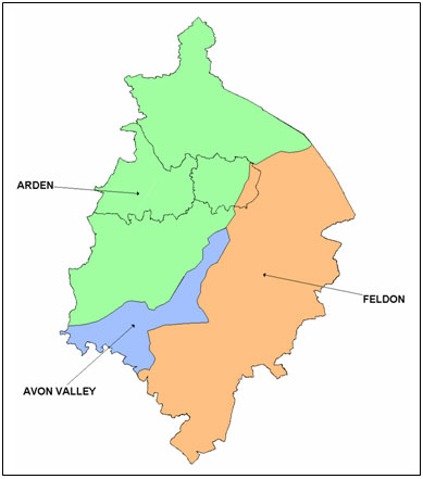
Figure 10 Warwickshire divided into the Arden, Feldon and Avon Valley
Traditionally, the county has often been divided into three parts: the Arden or ‘high land' of the north-west, two plateau regions that reach a height of over 150 metres separated by a valley drained by the rivers Tame and Blythe. The soils are predominantly heavy and rather acidic, developed upon Mercia Mudstone, but with a surface layer of lighter glacial drift in places. To the east is the raised plateau of the East Warwickshire coalfield with coal-bearing rocks outcropping along its north-eastern margin. This region was more heavily wooded than areas to the south - the site of the supposed ‘Forest of Arden'. Historically, this was the least populated part of the county, a slowly evolving landscape of scattered farms and fields with many patches of woodland and common waste.
Quite different is the flat plain of the Feldon or ‘open land' in the south of the county. A platform generally between 100 and 175 metres high, with heavy clay soils developed mainly on the Lower Lias, this was already an area of intensive crop cultivation in prehistoric and Roman times. It was later to be characterised by nucleated villages set amidst open field systems, some of the latter surviving until enclosure in the 18th and 19th centuries. The higher margins, including the Edgehill Fringe along the south-eastern boundary of the county and the area along the north-eastern boundary, were areas of rather later development in which stock pasture played a more important role in early medieval and post-medieval times.
Between Arden and Feldon, the valley of the River Avon runs south-westwards across the middle of the county forming a transitional zone, with lighter gravel soils either side of the river. To the east, on the Dunsmore plateau, gravel deposits overlie the clays. The Avon valley was also an area of relatively early development and by medieval times market centres had developed for the exchange of goods from north and south.

