Tithe Maps
Description:
Tithes were payments made to the local clergy in the form of a tenth of yearly production (crops, wool, milk etc.). Tithe maps were produced after the 1836 Tithe Commutation Act, which formalised the change from these production payments to money payments (i.e. rent). The maps were drawn on a parish basis with an accompanying apportionment schedule. The apportionment schedule lists landowners, tenants, descriptions of property, size of fields, land use and amount of rent payable. Most of the 168 Warwickshire Tithe Maps were produced in the 1840s and cover about 50 per cent of the county. The maps were usually produced on a scale of 3 chains to 1-inch, which is 1:2376 (approximately 25-inches to the mile), but many were produced at other scales. They record field boundaries and buildings.
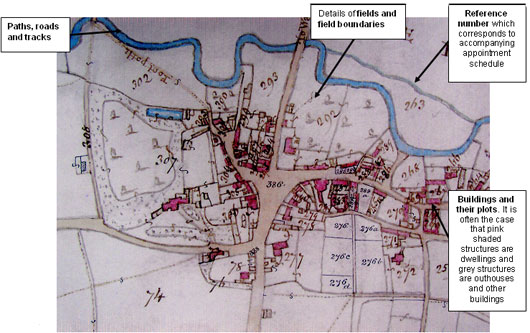
Figure 4: Tithe Map of Wellesbourne Mountford (Reference: CR 569/259)

Reproduced with kind permission from Warwickshire County Record Office
Click here for larger image
Uses:
Tithe maps, in conjunction with the appropriate apportionment schedule, are useful for identifying field boundaries, their names and sizes, roads and trackways, buildings, land use and ownership. Tithe maps were not standardised in scale or detail, and the quality of the maps can vary. Additionally, not all tithe maps cover an entire parish, since the tithes may have been commuted at an earlier date, perhaps during field enclosures. The maps need to be viewed in conjunction with the schedule, which can make them awkward to use because of their size and the need for careful cross referencing.
Tithe maps can be compared with other sources, such as Ordnance Survey maps, in order to chart changes in a landscape or settlement. Old maps can also reveal changes in place-names. It is probably worth consulting other historic maps alongside tithe maps. Maps can also be compared with other sources, such as trade directories, the Historic Environment Record, the Victoria County History and other such histories.
Where to find this source:
- County Record Office
- British Library Collections
- Limited availability on the Internet

